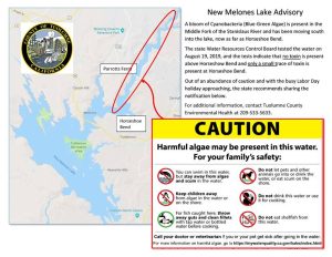
Sonora, CA — Officials are sharing the latest test results of a potentially harmful algal bloom between the Middle Fork of the Stanislaus River and New Melones Reservoir.
Tuolumne County Public and Environmental Health officials share that in preparation for the Labor Day Holiday Weekend, State Water Board staff tested the water around the lake Aug. 19 and the samples came back with low amounts of the same cyanobacteria as in the bloom that has been occurring in the river last month.
They report that cyanotoxins were not detected in most of the samples, just those taken further down from the river into the lake in the Horseshoe Bend area above Highway 49. These came back with low levels of microcystin well below the recreational caution advisory.
However, out of what health officials describe as an abundance of caution, signs have been posted in affected areas with safety instructions. Local health officials say the lake is signed on the Tuolumne County side of Melones from Parrotts Ferry, at both boat launches at Tuttletown, and all the way up the river to the log jam. You can view an example and a map of the area in question by clicking into the image box.
The signs specify that you can swim in the water but stay away from algae and scum and keep children away from the algae in the water or on the shore. Do not let pets or other animals into the water and do not allow them to drink the water or eat the scum on the shore.
They also direct folks to not drink the water or use it for cooking. For fish caught in the posted areas, throw away the guts and clean the fillets with tap water or bottled water before cooking and do not eat shellfish from the water.
Additionally, the Water Board’s Harmful Algal Bloom (HAB) Pre-Labor Day Assessment online map notes one yellow Caution marker in place on New Melones Lake at Horseshoe Bend above Highway 49. It also has five green No Advisory markers posted. These are at: the Mark Twain Day Use Area; Mouth at Soldiers Gulch below the Highway 49 bridge; Angels Creek; the Day Use Swim Area; Tuttletown Rec areas at Eagle Point and Manzanita Lower Loop; Angels Creek Day Use and Swim Area; and Glory hole Rec Area and Boat Launch.

