Cherry Lake

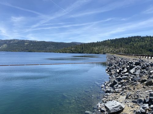
Fish and boat on the largest lake in the Stanislaus National Forest just outside of Yosemite’s borders in the Groveland Ranger District. Cherry Lake is open all year and perfect for summer recreation but in the winter road access via Cherry Lake Road (1N07) or from Sonora Fish Hatchery/Cottonwood Road (1N04) is subject to winter closures. The gate across the spillway and dam closes from December to April.
Cherry Lake and a large section of the forest was affected by the Rim Fire which began in August 2013. The lake was also drained in July 2017 to replace three of the four high flow release valves, details are here.
Cherry Lake visitors often feel they have the entire lake to themselves even though the lake is perfect for water sports, swimming, fishing, and hiking. The day-use area is on the West side of Cherry Valley Dam with a boat ramp and a designated swim area.
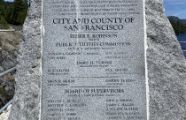
Cherry lake is fed by the North, East and West forks of Cherry Creek that begin in the Emigrant Wilderness and flow roughly southwest. The water from the lake (reservoir) powers the Dion R. Holm hydroelectric facility power plant. It was built by San Francisco as part of the Hetch Hetchy Project, which supplies drinking water to San Francisco. The City and County of San Francisco holds the rights to the water stored in Cherry Lake, human contact with the water is allowed (the water is filtered later).
Cherry Lake is at an elevation of 4,700 feet.
Camping
 Cherry Valley Campground is on the south west shore of Cherry Lake and has 46 campsites, 18 are first-come, first-served and the rest can be reserved on recreation.gov. There is dispersed camping (you can boat-in) on the east side. Open from late April through October.


Groveland Ranger District
24545 Highway 120
Groveland, CA 95321
Summer Hours (April – August)
Monday – Sunday 8am – 3:30pm
Winter Hours (September – March)
Monday – Friday 8am – 4:30pm
Saturday 8am – 3:30pm
(209) 962-7825 Phone
(209) 962-7412 Fax
(209) 962-6406 TDD
Fishing

If river fishing is your way to relax, these rivers should be your destination. Patient anglers who get up with in the early hours with the sun will be sure to catch their limit of trout and take in appealing vistas.
Hiking
 Andresen Mine Trail is moderate 4.5 mile hike with an elevation from 2100 to 1900 feet. Take Cherry Lake Road to one mile past the Kirkwood Powerhouse. Bear left onto 1S23Y and park off the road. Trail begins across the bridge. Use Jawbone and Cherry Lake South topographic quad.North Mountain Trail is a difficult three mile hike that climbs 2,500 feet in elevation. The trail follows the ridge line to an abandoned fire tower. Take Cherry Lake Road approximately 5 miles from the District Office. Approximately two miles past the Kirkwood Powerhouse, bear right and up off Cherry Lake Road. Continue bearing right and up for one mile to gated road. Park off the road, do not block the gate. Trail begins to the right, just in front of the closed gate. Use Cherry Lake South topographic quad.
Rafting

The most advanced whitewater in California: Class V Cherry Creek ranks up there with the most difficult whitewater in the entire United States. The river’s 15 Class V whitewater rapids are generated by the canyon’s steep gradient—the river drops more than 100 vertical feet per mile. Narrow and steep, the river is often choked with huge boulders. When you reach the bottom of a Cherry Creek rapid you’ll look back upstream exhilarated, and wish you could hike back up and do it again. Only two outfitters run Cherry Creek, few get to paddle this stunning stretch of the Tuolumne; your group will likely be the only one on the water. This exclusivity means Cherry Creek trips offer nearly private access to a remarkable and isolated canyon.Cherry Creek is a dam-controlled stretch of the Tuolumne River and becomes raft-able at lower flows, after the springtime snow melt. Trips usually begin in June and go through August.
Related Links
If you want to stay in the Mother Lode take a look our list of places to stay.
Planning a wedding, conference or other event? Take a look our list of places to host your event.
Tell us about your experience at this place! Contact Us
Events
Tuolumne Veterans Hall | 3:00 pm
Disney's Mary Poppins, The Broadway Musical
Bret Harte High School Theater | 2:00 pm - 7:00 pm
Tuolumne County Youth Centers
Jamestown Youth Center | 9:30 am - 5:00 pm
Calaveras County Public Access Television | 4:00 pm - 6:00 pm
Tuolumne County Youth Centers
Jamestown Youth Center | 9:30 am - 5:00 pm
Sonora Opera Hall | 5:00 pm - 7:00 pm
Tuolumne County Youth Centers
Jamestown Youth Center | 9:30 am - 5:00 pm
Calaveras Pregnancy Center | 12:00 pm - 4:00 pm
Calaveras Ranger Hiring Event
Calaveras Ranger Office | 5:00 pm - 7:00 pm
Musical Sanctuary: All Heart
Open Door UCC Murphys (formerly First Congregational) | 5:30 pm - 6:30 pm
Calaveras Master Gardeners Demonstration Garden | 11:00 am - 4:00 pm
Black History Month Film Series
Columbia College Ponderosa Student Center | 12:00 pm
Tuolumne County Youth Centers
Jamestown Youth Center | 9:30 am - 5:00 pm
