Second Week of June Highway Work Planned in the Mother Lode
Motorists can expect delays on Mother Lode highways this week…
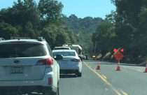
This map shows real-time local traffic conditions; green means the traffic flow is normal, orange means it is slower than normal, and red and dark red indicates slow and stopped vehicles. Updating Caltrans reports for each highway are below the map click or tap on the highway signs to jump to the road you are interested in.


1-way controlled traffic at the Contra Costa/San Joaquin Co Line
/at Old River Bridge/ 24 hrs a day 7 days a week thru 1900 hrs on 7/26/26
- Due to construction
1-way controlled traffic at various locations from the Jct of SR 99 to the
San Joaquinn/Stanislaus Co Line from 1900 hrs each night to 0700 hrs each
morning Monday thru Friday thru 6/12/26 - Due to construction
No traffic restrictions are reported for this area.
1-way controlled traffic at various locations from 0.2 mi west of
the Jct of SR 49 /at Main St/ to the Jct of SR 49 (Calaveras Co) from 0800 hrs
to 1800 hrs Monday thru Friday thru 6/12/26 - Due to maintenance
1-way controlled traffic at various locations from 0.2 mi north of the
Jct of SR 41 /at Junction Dr/ to 0.4 mi north of the Jct of SR 41
/at Meadow Vista Dr/ (Madera Co) 24 hrs a day 7 days a week - Due to
emergency work
1-way controlled traffic at various locations from 5 mi north of Bagby
/at Shilling Rd/ to 3 mi north of Coulterville /at Penon Blanco Rd/
(Mariposa Co) from 0600 hrs to 1600 hrs Monday thru Friday thru 6/12/26 - Due
to maintenance
1-way controlled traffic at various locations from 19.6 mi north to 20 mi
north of the Yuba/Sierra Co Line from 1000 hrs eo 1700 hrs thru Friday 6/26/26
-Due to construction
No traffic restrictions are reported for this area.
[CAPITAL CITY FREEWAY]No traffic restrictions are reported for this area.
No traffic restrictions are reported for this area.
A high wind advisory is in effect at the San Francisco-Oakland Bay Bridge
/in San Francisco/ (San Francisco,Alameda Co) - Travel is not recommended
for campers, trailers, or permit loads
The westbound connector to northbound I 5 /in Sacramento/ (Sacramento Co)
is reduced to 1 lane - Due to emergency work
All westbound trucks are required to stop at the brake check area
0.5 mi west of Nyack (Placer Co) - To reduced the risk of brake fires
No traffic restrictions are reported for this area.
No traffic restrictions are reported for this area.
A high wind advisory is in effect from the Stanislaus/San Joaquin Co Line
to the San Joaquin/Sacramento Co Line - Travel is not recommended for campers,
trailers, or permit loads
No traffic restrictions are reported for this area.
1-way controlled traffic at various locations from 9.5 mi to 11.3 mi east
of Dardanelle (Tuolumne Co) from 0700 hrs to 1600 hrs Monday thru Friday thru
6/8/26 - Due to construction
[YOSEMITE NAT'L PARK]
For Yosemite Nat'l Park road information call 209-372-0200
1-way controlled traffic at Second Street /in Escalon/ (San Joaquin Co)
from 0900 hrs to 1500 hrs Monday thru Friday thru 6/12/26 - Due to maintenance
For Yosenite Nat'l Park road information call 209-372-0200
Roads Info Last Updated: Monday, 8th of June 2026, 11:59:16 PM