




Sonora, CA – Yosemite National Park officials have a rundown regarding eight lightning-strike fires in the park, and Stanislaus National Forest updates the Woods Fire.
As we reported here earlier this week, the Woods Fire, also caused by a lightning strike, was 65 acres and 45 percent contained. Forest fire officials update that the acreage remains the same, but the blaze is now 100 percent contained. The Woods Fire ignited in Woods Gulch, a steep, rocky, high-elevation area in the Carson-Iceberg Wilderness about two miles northwest of Clarks Fork Campground and east of the Dardanelles.
“Crews and resources have been released back to their home agency or reassigned to other incidents. Engine Squad E332 remains on site. Two helicopters from Bald Mountain Helibase and the Stanislaus National Forest Pack Stock program continue to support the crews as needed,” according to forest fire officials.
Firefighters will remain at the site and monitor the blaze through the weekend. The public is asked to use caution in the area and be aware that drift smoke may be visible.
Yosemite National Park currently has eight new lightning-strike wildfire starts, all attributed to an early morning storm on August 12, 2026. Officials advise that no site closures or evacuations have been enacted due to the fires, as detailed below.
Two Fires in Aspen Valley Area:
ACKERSON:
- Location: Less than 1 mi West of Aspen Valley
- Elevation: 6,300’
- Discovery date: 08/12/226
- Cause: Lightning
- Size: 1.5-acre
- Status: 50%
- Contained – Staffed YNP E63/CNF E338
LONG:
- Location: 1 mi South of Aspen Valley
- Elevation: 6,000’
- Discovery date: 08/12/2026
- Size: 1/10th acre
- Status: Contained – Unstaffed

Fires in the Ackerson Meadow area of Yosemite National Park—Yosemite map
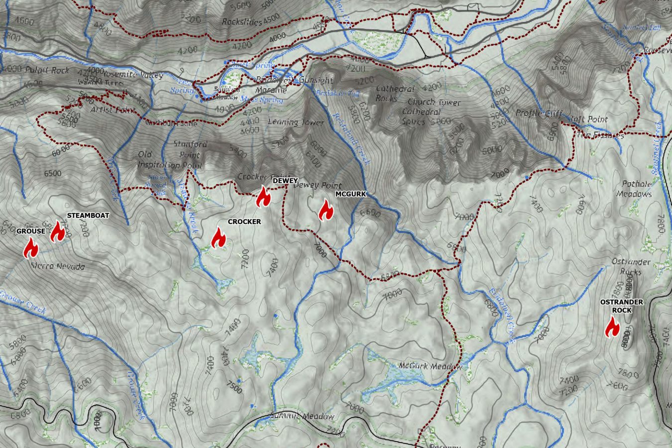
Six fires in the Glacier Point Road area:
GROUSE:
- Location: Grouse Creek, less than 1 mi from Hwy 41
- Elevation: 6,000’
- Discovery date: 08/12/2026
- Size: 2 acres
- Status: 30% contained – Staffed Hollister Helitack/STF Crew 91
STEAMBOAT:
- Location: Grouse Creek drainage top 1/3, less than 1 mi from Hwy 41
- Elevation: 6,900’
- Discovery Date: 08/12/2026
- Size: 1/10th acre
- Status: Uncontained/Unstaffed
CROCKER:
- Location: Meadow Brook drainage, less than 1 mi from Inspiration Trail
- Elevation: 7,000’
- Discovery date: 08/12/2026
- Cause: Lightning
- Size: 1/10th acre
- Status: Uncontained – Staffed ANF E326
DEWEY:
- Location: Dewey Point adjacent
- Elevation: 7,300’
- Discovery date: 08/12/2026
- Cause: Lightning
- Size: 1/10th acre
- Status: Uncontained/Unstaffed – Fire located over cliff edge
MCGURK:
- Location: 1/4 mi East of Dewey Point, North of Inspiration Trail
- Elevation: 7,000’
- Discovery date: 08/12/2026
- Cause: Lightning
- Size: 1/10th acre
- Status: Uncontained – Staffed STF C91
OSTRANDER:
- Location: 1 mi east of Bridalveil Creek, less than 1 mi from Glacier Point Road
- Elevation: 7,800’
- Discovery date: 08/12/2026
- Cause: Lightning
- Size: 0.5-acre
- Status: Uncontained – Staffed YNP E32