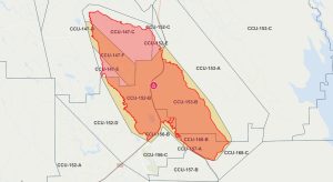
Update 1:30 p.m.: All evacuation orders have been lifted for the Aero Fire burning in the Copperopolis area of Calaveras County.
CAL Fire updates that evacuation warnings remain in place for CCU-147-F, CCU-152-B, CCU-153-B, CCU-156-B, CCU-157-A, and CCU-168-B. All road closures have been lifted. The public is reminded to stay vigilant on current fire conditions. Drive slowly and yield to emergency personnel in the area. There will still be smoke in respective areas as firefighters continue operations. Do not enter red-tagged structures; they are not safe. The Aero Fire remains at 5,351 acres, and there is now 67% containment.
Original post written by BJ Hansen at 8:02 a.m.: Copperopolis, CA — There was minimal fire activity witnessed on the Aero Fire overnight, as it remains 5,351 acres, and there is now 67% containment.
Firefighters continue to patrol the area, build additional fire line, and extinguish hot spots. Damage inspection has been completed and the impacted property owners have been notified. Three structures were destroyed and one additional building was damaged.
CAL Fire adds, “Smoke will be visible within the fire’s boundary for potentially several weeks and is not a concern as firefighters will be actively patrolling the area. Remember that crews remain in the area; please use caution when driving.”
To view the latest evacuation map, click here.
Road closures still in place include Pyle Rd. at O’Byrnes Ferry Rd, Rock Creek at Highway 4, Britchen Dr. at the Fire perimeter line, Rock Creek at the fire perimeter line.

